
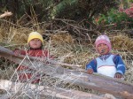
A few moments to myself on top of Putucusi (the mountain across from Machu Picchu)
A few moments to myself on top of Putucusi (the mountain across from Machu Picchu) a video by jessicabruck on Flickr.
Correction… The mountain on the left is Machu Picchu Mountain. The Mountain on the right is Wayna Picchu.
Cuzco: The Sacred Vally (Pisac, Ollantaytambo, Chinchero)
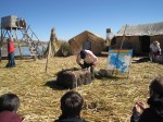
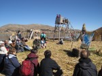
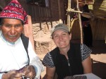
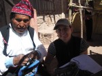
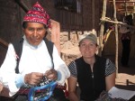
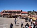
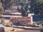
I arrived in Cuzco on Saturday, taking a bus from Puno that stopped at various historical sites along the way. One in particular, Raqchi (and the temple of Wiracocha), was interesting to me as it was the first well-defined Incan site I had spent any time at.
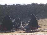
 Wiracocha was the 8th Incan King. Just as interesting to me as the history of the ruins was the the construction. Take a look at the pictures below…. what pops out to you?

Just how did the Incas manage to make the stones fit so closely???


What is that shape that keep appearing over and over again? Any ideas as to why?
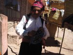
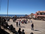
So now I am in Cuzco. Cuzco is the base from which I am going to explore Incan ruins in the Sacred Valley, do my 5 day trek to a lesser known lost Incan city of Choquiquerao and then finally, go to Machu Picchu.

I will be based out of Cuzco for almost 2 weeks! It feels nice to be in one place for awhile though.
After checking into my hotel on Saturday, I went to the tour company through which I had arranged my trek out to the Incan ruins of Choquiquerao to confirm my trip on the 4th. The trek will be for 5 days and I am really looking forward to it, as I will have the chance to see two major Incan ruins and not just Machu Pichu as most people do. I also arranged train tickets and entrance to Machu Pichu on the 10th-11th. Apparently, a lot has changed in Peru in the last three weeks with the new President and you cannot just show up at the archeological site and buy tickets anymore.
With that settled, I took up the opportunity to do a tour of the Sacred Valley on Sunday. We went to three major Incan ruins. Something to know about the Incas is that they were only really a dominating civilization for 90 years or so. They became powerful quickly and extended their reign from Ecuador into Chile by absorbing existing communities and also, improving upon technology that already existed.
The first major stop on our Sacred Valley tour was Pisac. The archaeological complex is a fantastic example of Incan terracing. Most of which were still in use until major flooding happened in the Sacred Valley in 2010.

The terraces are made up of four layers. On the bottom is rock, for drainage, then gravel, then sand and finally the top layer is humus, rich earth in which crops grow. What is fascinating to me is that underneath all of this, the Incas first built water irrigation channels, so there are actually little streams of water running underneath the terraces.

OLLANTAYTAMBO:
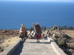
Our next stop was Ollantaytambo, a huge agricultural and economic center for the Incas in the Sacred Valley. What was interesting was that it was also an unfinished temple, on which the sun shone directly upon on the Summer solstice. These Pre-Colombian civilizations really are fascinating when you think of their ability to build things in just exactly the right place so it is hit by the light on one particular day of the year!


This was the first site that I really got to see just how HUGE the blocks of granite are that the Incas used to build their temples and cities. I don´t have the information with me just now, but some of the blocks for the temple (above middle) weigh something like 45 tons and came from a quarry over 5 kilometers away over a mountain! A few years ago, the townspeople of Ollantaytambo actually moved a block, though much smaller by placing logs underneath the block just to prove that it was actually possible to move them using non-machine generated power. It is estimated to take something like 15 people to move a 1 ton block. Just think about how many people were involved in moving them! Needless to say, I left the site impressed!
CHINCHERO
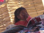
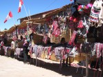
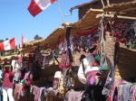
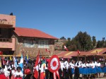
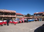
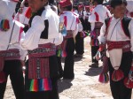
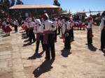
The last stop on our tour of the Sacred Valley was to Chinchero, another town with terraces, but better known for its textiles and natural dying of wool from the plants and insects in the surrounding environment. You can bet Ms. Bruck was excited about this stop!


The colorwork and detail in their weaving is pretty incredible! How much counting do you think is involved in that? I spoke with one of the ladies, and she confirmed for me that it was all about patterns, different number combinations gave different shapes, slopes of the shapes as you went from row to row, etc. 🙂

I bought some fabric from the lady to my left and in response they decided to dress me up in their traditional dress and have my picture taken. I look pretty silly, but it was a good laugh!
Today my plan is to do a “city tour” of some Incan ruins outside the city on my own. There is so much information that you get with a guide, but I often find myself rushed through and not getting to spend as much time exploring as I would like!
Cheers!
Ms. Bruck
VID00647
VID00647 a video by jessicabruck on Flickr.
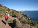
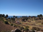
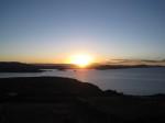
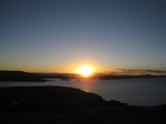
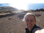
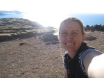
The view from the highest point on the island of Amantani, Lake Titicaca, Peru
Puno, Lake Titicaca and the floating islands of Uros and the “knitting islands” of Amantani and Taquille
In Puno, on the shores of Lake Titicaca for the night and heading to Cuzco tomorrow. There were so many pictures to upload from my recent three days and two nights on the islands of Lake Titicaca, that I am hoping a slideshow with captions will help to translate the amazing experience much better than I ever could in writing. 🙂
Note: I realize now that the slideshow does not show the captions that I wrote for each picture. I added the gallery below, which does seem to have most of the captions, but out of order. Since I´ve been at the computer for almost 3 hours now (it takes awhile to upload!) I´m going to leave it and try to fix it in a few days. Regardless, I hope you can piece together the story in the photos until I do!
Ms. Bruck
-
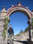
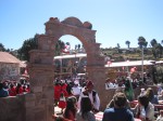
- Went for a nice little hike around the island of Taquille and came across many arches. The red flowers above are used to dye the wool they knit with on the island.
-

- Sheep on Taquille= wool= knitting. 🙂
-

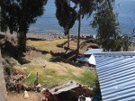
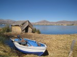
- Outside the front of homestay in Amantani… so much of my time on these islands reminded me of Tanzania
-

- Room at homestay on Amantani. The luxury of solar panels meant light at night!
-

- The Señora of our homestay on the island of Amantani came to meet us… you can she her spinning wool as we walk along the beach back to her home.
-
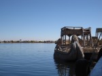
- The floating islands of Uros have been in existence for over 900 years. The inhabitants have to constantly add more reeds to the top layer in order to replenish the rotting reeds below.

-
- Waiting for an informative session about the history and construction of the floating islands.
-
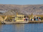
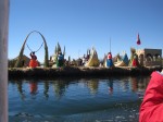
- A first glimpse of the floating islands of Uros
-
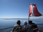
- Start of boat ride across Lake Titicaca to the floating islands of Uros, and the “knitting islands” of Amantani and Taquille
-

- I ended up knitting with this man from the Island of Taquille most of the boat ride back to Puno. So interesting to compare techniques and patterns!
-
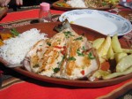
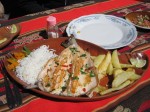
- Amazing trout for lunch on the island of Taquille!
-
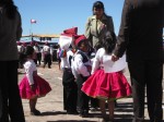
- Traditional dress on the island of Taquille. They swear they dress this way everyday, not just on Independence Day.
-
- This man took the time to explain to me the meaning of the different symbols in the belt that I bought from him. It was such a nice exchange. He seemed genuinely excited that someone wanted to know the meaning behind the object that they had bought!
-
- Men knit on the island of Taquille, while women spin the wool and weave the belts that the men wear. Men knit their hats: Red means “married” and Half red/ half white means “single”
-
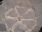
- One symbol the appears over and over again is the “6 suyos”. According the man I bought the belt from, these are 6 crops, or elements of sustanence on the island, such as quinoa, corn, fish, etc. According to the internet, it is the 6 communities on the island. I guess I will have to do more research!

-

- Inspired by all of the knitting and weaving around me, I find a some time to knit on the boat ride from Amantani to Taquille.
-
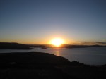
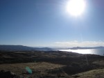
- Sunset over Lake Titicaca. Island of Amantani
-
- Stealing a few moments by myself before the sunset.
-
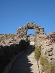
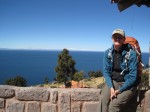
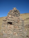
- Incan ruins: Entrance to the top of PachaMama, the highest point on the island of Amantani.

-

- Random building on the island of Amantani… geometry is everywhere!


Almost time to say goodbye to my homestay…and trekking in the Colca Canyon.
Today was my last day in Arequipa. I spent it being a complete tourist, taking the red hop on/ hop off bus tour around Peru`s second largest city. Yep, they have those here too. Just as in other city´s I´ve been, not all of the stops pertained to my particular interests, but it was a good way to see a lot of the city in a short amount of time. I will be sad to say goodbye to Lucy and Marcela and also, Cet and Milagros, my two Spanish teachers while I have been here. Thank you all for making me feel welcome and giving me the confidence needed to go forth with my (previously rusty) Spanish skills!
-

Outside of my homestay with Spanish Teacher, Cet, and homestay "mom" Lucy


Me, Milagros, Lucy

Spanish Teacher Milagros

Spanish Teacher Cet
COLCA CANYON AND PRE-INCAN TERRACES:
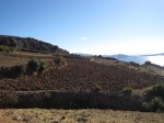
Taking with me only what I needed and leaving most of my belongings at my homestay, I went to the nearby Colca Canyon this weekend. The Canyon is famous for its Pre-Incan terraces, 70% of which are still in use farming today, a bluff known as the “Cruz del Condor,” where one can see Condors with wingspans of up to 3 meters long soaring above you, and Peru´s second deepest canyon ( 4,160 meters, which is just how high kids….). I think that is about twice as deep as the Grand Canyon in Arizona. It was absolutely breathtaking.

Pre Ican Terrace farms still in use: Colca Canyon, Peru
You can see the terraces below still in use. If you look closely, way up high in the mountains, there are lines across the hillside…. these are Pre-Incan and Incan terraces farms no longer in use. What a crazy example of “slope.” It amazes me to think that people actually farmed on terrain that steep!


The Condors were pretty breathtaking to watch. Photos and pictures can do justice to none of this trip, but I will try to post a short video I took of the Condors in a little bit.

Our trek started up at just over 3300 meters. The altitude here is amazing! We actually drove up and over the mountains at 4900 meters (16,079 ft!) just to get to the Colca Canyon. From our starting point, we descended over 1200 meters to the valley and river below. I know from backpacking that downhill is ultimately harder on your body than uphill! Three and a half hours later, we arrived at the bottom, gratefully for some shade. Despite it being the middle of winter here and freezing as soon as the sun sets, it is warm enough to give me quite a sun burn during the day!


After reaching the bottom of the Canyon and crossing the river, which ultimately drains into the Pacific Ocean, we hiked up to a small village (50 people), where we had lunch. The hike after lunch, which meandered through the villages and followed the water irrigation system/aqueducts was my favorite part of the hike. There were a few hills, but overall, it was fairly relaxing. I wish I had taken more pictures of the acquaducts as they were quite simple yet amazing.


Our guide, Cariña, giving details about a local shrine, which pays respects to both the local customs (the moutains) and Spanish/Colonial Influences
We arrived at the Oasis, where we would spend the night, about 40 minutes or so after dark. A piece of advice… always keep your headlamp someplace where it is easy to locate in your backpack! I never think I am going to need it at the beginning of the day when I pack my back, but it´s amazing how many times I´ve had to look for it, after it has already gotten dark!
The next morning, we woke up at 4:30am to start the 1,010 meter hike back up the hill to the village of Cabanaconde, where we would get breakfast and the bus back to Arequipa. This climb was no joke! It was strenuous enough that no less than 15 people chose to hire mules to ride back up to the top! I cannot even imagine how sore I will be after my 5 day trek to Choquequirao later in the trip, as I was plenty sore after this short, 2 day trek! It looks like Ms. Bruck needs to start hiking, backpacking, running and climbing more in general again!

Back up at the top of the canyon and ready for breakfast!
People still dress very traditionally in this part of the country. I am very shy about taking photos of people, but I do have these three. Aren´t the textiles beautiful? These women are not just dressed up to sell their wares to tourists! We actually saw virtually all of the women throughout the valley dressed in the same traditional manner. It is awesome to know that at least some parts of cultures prevail once exposed to the outside world.
Ms. Bruck


Arequipa: Homestay, Spanish Lessons and Mundo del Alpaca
I´ve been in Arequipa for four days now, staying in the family home of the director of a Spanish Language school for foreigners here in Arequipa. It feels great to be in the same place for a longer length of time and great to be living with a family. I never really settled into really spending time with my host families when I lived in Spain and during my Peace Corps Training in Tanzania, but it seems to be so much easier this time around to let go of that American need to do things on their own terms and schedule. When I am not doing my four hours of language courses in the afternoon, I spend most of my time with my Señora, Lucy, and her househelper/cook, Marcela. Maybe it`s just that I have found the perfect family for me to spend time with because most of the time we spend together……. knitting. Yep, that is right. Everyone in my homestay family is obsessed with knitting. Perfect!
Yesterday, Lucy and her cousin took me to Mundo del Alpaca, which is a (more modern) store of alpaca products that also acts as a museum and export center. It was pretty awesome to see both Alpacas and LLamas, their wool after it has been shaved off, and the process that it goes through to become yarn. They also had some weavers from the Cuzco area, doing demonstrations of traditional weaving. The colors are amazing! And you know I can´t avoid talking about it….. the patterns, well, there MUST be at least a bit of math involved! Finally, we spoiled ourselves by spending almost a full hour in the stock room, where I saw where they gather wool that I see both at Michaels, and smaller independent yarn stores packed up and ready for export.
SORRY THE PICTURES SEEM TO BE OUT OF ORDER AND BIT OF A MESS! AT THIS POINT, WITH LIMITED TIME ON THE COMPUTER, I AM JUST HAPPY TO GET THEM UPLOADED!
🙂


We also went to the market in order to buy Lucy some new knitting needles, so I could show her how to make gloves. The store than sold the knitting needles is around the corner from the big market below, but it was too interesting a place not to show you. The best way I can describe it is that is was something like that big market in Tanzania, but much more organized and cleaner!


Nasca Lines 2 trapezoid shapes
Nasca Lines 2 trapezoid shapes a video by jessicabruck on Flickr.
Nasca Lines 1
Nasca Lines 1 a video by jessicabruck on Flickr.
Nazca Lines- Mystery, Archaeology and Geometry
Warning: I took many pictures, but few are uploading due to slow internet speeds. I will do my best to upload, but am trying to link to other people’s websites (and pictures and videos) in order to give you a better idea of what I am talking about until I get my own loaded.


- Pictures taken from a scale model of the Nasca Lines in the Nasca Lines Hotel, Nazca, Peru
I really like the little town of Nazca, in desert plateau on the Southern Coast of Peru. I was first interested in coming here when I came across this website five years ago when I was looking for other things to link math to. No one knows exactly why the Nazca lines were made, though there are many theories. There seems to be three main theories: they marked how to find water; they marked some type of calendar, with lines pointing in the direction of the sunset on the Winter and Summer soltices; and the animorphic shapes represent constellations in the sky.
Take a glimpse here for a quick peek at what I’m talking about.
When most people find out about the lines, they notice the animorphic shapes. Actually, the geometric shapes are MUCH larger than the animorphic shapes. Here are just a few of the things that I learned last night at a small presentation at the Maria Reiche planetarium in the Nazca Lines Hotel:
- The lines were formed by the Nazca people 100-600 A.D by removing the rocks from the desert basin, leaving just the fine dirt below exposed.
- With the exception of the Monkey, all shapes are made from one single line that never crosses itself.
- 30% of the the large geometric shapes (triangles, trapezoids, and rectangles) are known to point to the source of water, an extremely valuable resource in the desert.
- The lines that point to the sources of water are actually perpendicular to the Rio Grande.
- Other sets of lines are perfectly parallel sources that come down from the mountains.
- The lines reach up to 480 meters long in some cases.
- It is believed that at times Nazca gather on the lines for ceremonies and at other times, they would walk and follow the lines until it lead them to sources of water.
I took at flight over the lines this morning and it was pretty spectacular! Unfortunately, my video did not turn out amazing, but I tried to share what I have with you in the posts above. I hope it works!
Ms. Bruck
Packed and ready to go…. (just barely)
Wooo Hooo! I’ve managed to squeeze everything that I’m going to need for the next month of travel into my smaller (40 Liter) backpacking backpack and a day pack.  I think that I’ve packed less than I did for the two weeks I just spent with my family in California. I know for sure it’s less than some of you students packed for the wilderness trip as freshman! It was no easy feat, considering the following:
1. It’s winter in Peru right now. The whole northern vs. southern hemisphere seasonal flipflop threw me for a loop when I stopped to think about it. This means that there are lots of warm (and bulkier) layers of clothes and a jacket, hat, gloves, etc. in that pack.
2. I’m bringing a sleeping bag. Part of my fellowship travels will include a 5 day long backpacking trip to Choquequirao, a lesser known (less tourist ridden) Inca ruin and lost city. Since it’s going to be winter in Peru, I feel pretty strongly about bringing a sleeping bag that I know is going to keep me sufficiently warm at night. Also, I’ll be taking a few long-distance overnight buses, which I heard get pretty cold at night. It will be nice to have the sleeping bag for that as well.
3. I’m also going to be in the desert to see the Nazca Lines and in much warmer places, so I had to make sure that I have at least a few clothing items for warmer weather as well.
I’ve decided not to bring the laptop computer, which will make posting on the blog a bit trickier, but it will make my overall experience much more enjoyable I think. From past travels abroad, I’ve learned that bringing as few valuables as possible not only saves on the overall weight of my backpack, but also saves on worry and stress. I think it will be fine as internet cafes are supposed to be fairly ubiquitous (at least in the slightly larger cities) in Peru.
Looking forward to my next post coming to you from within the country to Peru as my flight to Lima (Peru’s capital) takes off in less than four hours!
Ms. Bruck
